Alpine-sourced Landslides
Alpine-sourced Debris Flows
Many of the geologic hazards in Alaska are associated with unstable slopes that have the potential to rapidly mobilize, the result of which could be loss of life and significant damage to property, infrastructure and economy with little or no warning.
Ice/Rock Avalanches
Changes in the cryosphere (e.g. glacier wastage and retreat and thawing of permafrost), are thought to be responsible for the rising number of mass movements in high-latitude and high-elevation areas. Such changes in Alaska are exacerbated by rising air temperatures, high amounts of precipitation, snow avalanching, and strong ground motions caused by frequent moderate to large earthquakes.
CCHP uses field-based observations, remotely sensed data (photogrammetry, lidar, optical satellite, ground-based radar interferometry and GNSS surveying techniques) and geospatial analyses to identify changes in geologic processes that threaten people, resources and infrastructure.
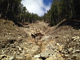
Debris flows are dangerous natural hazards that occur throughout Alaska. In many areas of the state, debris flows threaten public safety and infrastructure and can lead to lengthy closures of important transportation routes. CCHP began a collaborative study with the Department of Transportation & Public Facilities (DOT&PF) along the Haines Highway corridor near Haines, Alaska. The intent of this study is to evaluate, monitor and model geophysical processes, including cryosphere-related changes, along this important transportation corridor, where destructive debris flows regularly impact the highway by threatening motorist, damaging infrastructure and impeding traffic flow. (Co-Investigator: Ronald Daanen, DGGS)
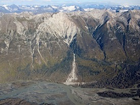
One of the major debris channels along Haines Highway. Photo credit: Gabriel Wolken, DGGS.
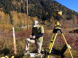
Collection of GNSS data during airborne photogrammetric survey of debris flow terrain along Haines Highway. Photo credit: Gabriel Wolken, DGGS.
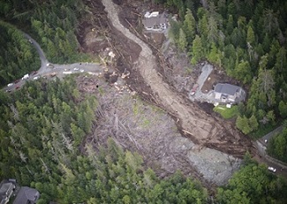
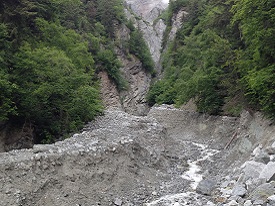
Devastation from the Kramer landslide in Sitka, 2015. Photo credit: Gabriel Wolken, DGGS.
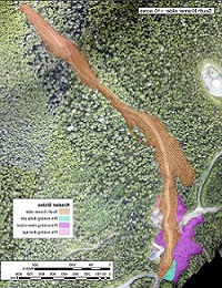
Extent of the August 2015 South Kremer debris flow and surrounding pre-existing features. Image credit: CCHP.
In August of 2015 a debris flow disaster stroke Sitka that involved over 40 slides on Baranof and Chichagof Island, resulting in massive damage to property and infrastructure. The largest slide on Harbor Mt, the Kremer slide, killed three people. These flows were water-laden, fine-grained and travelled at high velocities, carrying a significant amount of large, woody debris. CCHP personnel were sent to Sitka to assist with the emergency response effort. CCHP's main effort was to rapidly acquire and process airborne optical remote sensing data, and deliver a draft level product for operational use by ground teams, i.e. geologists, engineers, emergency response personnel, and local government officials. DGGS participates in a multi-agency workgroup (DGGS, NPS, USFS,CRREL, City of Sitka, FEMA, and Sitka Sound Science Center) that advises on the development of a debris flow warning system , and continues to acquire remote sensing data (ground-based geophysics and lidar) to assess and model debris flow activity in the Sitka area.
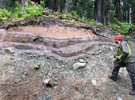
Geologic investigation of soils and bedrock to understand the release of landslides in Sitka, southeast Alaska. Photo credit: Gabriel Wolken, DGGS.
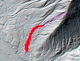
Matching the South Kremer slide with the Laharz debris flow prediction model. Image credit: CCHP.
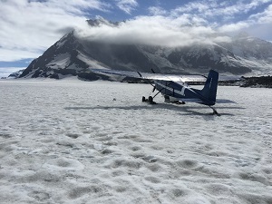
Airborne photogrammetric survey of the rock avalanche that released on Lamplugh Glacier in June, 2016. Photo credit: Gabriel Wolken, DGGS.
Fjords in south-central Alaska are geologically young (glacierized and recently deglacierized) and dynamic settings. CCHP is investigating large, unstable slope activity in south-central and southeast Alaska in an effort to understand the potential hazards to communities and infrastructure in these areas, and to support proactive planning, hazard mitigation and emergency response preparation.
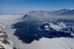
In July of 2016, a mountain slope above the Lamplugh Glacier, located in Glacier Bay National Park, collapsed and released a massive rock and ice avalanche. The run-out zone covered more than 20 sq km and came to a stop only 7.5 km from John Hopkins Inlet. Alaska Earthquake Center recorded the seismic activity caused by the avalanche as an M=2.9 event. CCHP conducted airborne photogrammetric surveys following the event to produce a digital surface model and a high-resolution orthophotos. These products are being used by CCHP and collaborators to understand the details of this significant ice/rock avalanche and improve our knowledge of the triggering mechanisms behind these large-scale, destructive events.
Gabriel J. Wolken, Ph.D.
Climate & Cryosphere Hazards Program
Program Manager
Phone: 907-451-5018
Email: gabriel.wolken@alaska.gov
Katreen Wikstrom Jones, M.Sc.
Climate & Cryosphere Hazards Program
Hydrologist
Phone: 907-451-5006
Email: katreen.wikstromjones@alaska.gov