History and geologic evidence show that tsunamis are a significant threat in Alaska. Furthermore, many southern coastal communities are located directly above tsunamigenic earthquake sources and will have very little, if any, time to respond to a tsunami threat following a major earthquake. The National Tsunami Hazard Mitigation Program (NTHMP), through the Alaska Division of Homeland Security & Emergency Management (DHS&EM) and National Oceanic and Atmospheric Administration (NOAA), is committed to reducing the impacts of tsunamis in Alaska by identifying, mapping, and modeling hazards, coordinating real-time warnings, and increasing awareness and encouraging preparedness in communities.
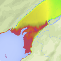
DGGS collaborates closely with the Alaska Earthquake Center and Geophysical Institute at the University of Alaska Fairbanks to help the NTHMP identify at-risk coastal communities in Alaska and provide tsunami hazard maps for hazard mitigation and emergency response training. We select communities based on their tsunami hazard exposure, location, infrastructure, availability of data, and willingness to incorporate results in a comprehensive mitigation plan. We also travel to communities to present the latest publications and raise awareness about known risks.
In conjunction with the U.S. Geological Survey, DGGS also participates in collaborative research along the Aleutian subduction zone aimed at understanding the recurrence and size of large paleoearthquakes and tsunamis.
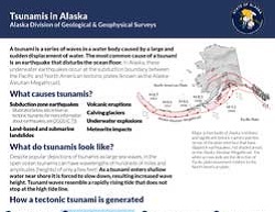
Read more general information about tsunamis in Alaska in our latest Information Circular.
J. Barrett Salisbury
Earthquake and Tsunami Hazard Program Manager
Phone: 907-451-5974
Email: barrett.salisbury@alaska.gov