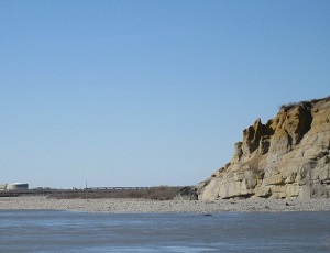
Abandoned oil rig on the tundra near the Gubik gas field. Bluffs along the Colville River are visible in the distance.
After nearly six decades of commercial oil and gas production in Alaska, the North Slope and Cook Inlet sedimentary basins still host enormous, untapped petroleum potential. Recent discoveries on the North Slope, including about 1.2 billion barrels of recoverable oil in sandstones of the Nanushuk Formation in the Pikka unit and approximately 300 million barrels of recoverable oil in the Willow unit, are tangible examples of the remaining potential. Recent estimates by the U.S. Geological Survey (USGS) of undiscovered petroleum resources in conventional reservoirs from the onshore part of the Arctic Alaska petroleum province include mean volumes of over 24 billion barrels of oil and over 85 trillion cubic feet of natural gas, and estimates for Cook Inlet basin (northern Cook Inlet and OCS) include mean volumes of over 1.6 billion barrels of oil and over 20 trillion cubic feet of gas. To put this into perspective, in 2017, preliminary data suggests the United States consumed a total of 7.26 billion barrels of petroleum products, an average of about 19.88 million barrels per day.
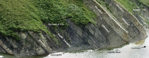
Moderately dipping strata (layers of rock) in the uppermost part of the Nanushuk Formation at Ninuluk Bluff, along the Colville River. Sandstones in the Nanushuk host large accumulation of oil in the eastern National Petroleum Reserve Alaska and on state land immediately east of the Colville River. Photo credit: David LePain, DGGS.
In addition to these two prolific hydrocarbon-producing basins, there are several lesser known sedimentary basins in Alaska, such as the Yukon Flats and Nenana basins, whose geology suggests they could host commercial quantities of petroleum. Finding and producing these resources is critically important for the state's economy and the livelihoods of thousands of Alaskans, but doing so requires a detailed understanding of the geology that hosts them, including stratigraphy, subsidence and uplift histories, and knowledge of proven and hypothetical petroleum system elements.
The Energy Resources Section generates new, unbiased information on the geologic framework of frontier sedimentary basins in Alaska that may host undiscovered oil and gas resources to promote exploration and production success. This information is available for free as high-quality reports and geologic maps from the our website. The Energy Resources Section also occasionally leads field trips, highlighting geology relevant to Alaska's petroleum basins, and core workshops at the Geologic Materials Center featuring petroleum source and reservoir rocks. In addition, a searchable digital database is under development to host the section's digital data and make them accessible to the public. The section works in close collaboration with the Alaska Division of Oil & Gas and the U.S. Geological Survey on all of its projects.
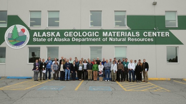
Group photograph showing participants in a half-day core workshop led by DGGS and DOG focusing on the oil potential of the Nanushuk Formation. Photo credit: Peter Flaig, Texas Bureau of Economic Geology.
Outcrop of the Sagavanirktok Formation on the east side of the Sagavanirktok River. Pump Station 2 and the Trans-Alaska Pipeline are visible in the distance. Photo credit: Marwan A. Wartes, DGGS.
Recent work by the Energy Resources Section includes: discovery of a thick Jurassic sand body south of Tuxedni Bay that appears to be part of an exhumed, conventional oil reservoir; documentation of large submarine canyon-fills in Mesozoic strata in lower Cook Inlet; provenance and reservoir quality of Tertiary sandstones in upper Cook Inlet; and detailed study of the Nanushuk Formation in cores from four exploration wells in the National Petroleum Reserve-Alaska (NPR-A). Work also includes inch-to-mile geologic mapping projects of economically important formations straddling the Trans-Alaska Pipeline corridor in the Sagavanirktok Quadrangle, Cretaceous strata in the vicinity of Umiat oil field and Gubik gas field, Tertiary strata deformed by complex fold and fault structures associated with the Castle Mountain and Moquawkie fault systems in the Tyonek Quadrangle, a short distance west of North Cook Inlet and Beluga gas fields, and Mesozoic sedimentary and plutonic rocks in the Iniskin-Tuxedni region. These mapping projects were undertaken to help unravel the stratigraphic and structural histories of these high-potential areas.