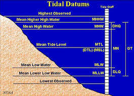
Unambiguous vertical datums in the coastal environment are critical to the evaluation of natural hazard vulnerability in support of local and regional planning. Appropriate tidal data must be considered in the siting, design, construction, and operations of development projects to ensure protection of human life, property, and the coastal environment.
The NOAA Center for Operational Oceanographic Products and Services (CO-OPS) provides infrastructure and expertise for all verified tidal measurements and is the ultimate authority on tidal datums in the United States. NOAA's National Geodetic Survey maintains the National Spatial Reference System (NSRS) that is used to relate tidal datums to geodetic datums. The minimal record of water level measurements and limited survey control in our state prevents the widely-used VDatum program from being available for most of Alaska's coast. DGGS has identified a critical need to improve awareness and facilitate access to tidal datum information in Alaska during this interim period.
Help update the Tidal Datum Portal, improve the National Spatial Reference System, and facilitate public access to Alaska benchmarks by collecting GPS data and making a contribution to the shared Online Positioning User Service (OPUS) database.
This conversion calculator is provided as a convenience to facilitate access to vertical measurements that have been independently verified and are freely available from either NOAA CO-OPS or NOAA NGS. For rigorous emergency, planning or construction purposes, users are strongly advised to consult these original sources to ensure accurate and up-to-date transformations. All calculations are based on single tide station offsets, elevations obtained using this method are only valid in the immediate vicinity of the original tide station. Because the relationships between local tidal and geodetic elevations can change with time, the most up-to-date measurement sources must be consulted, independent of this site, to ensure accurate transformations for these high-stakes applications.
The values in this conversion calculator were last updated December 2023.
A summary of relevant information, including links to all of the published values included in this calculator, can be found in the reference table. The table includes all Alaska tide stations with published local datums, however, tidal benchmarks or NAVD88(GEOID12A) tidal benchmark elevations are not available for all locations.
Conversion between local tidal datums and NGVD29 is not supported by the calculator at this time.