As the most northern and largest state in the United States, Alaska has more glaciers than any other state. Alaska also has more volcanoes than any other state, and many of Alaska's volcanoes are (you guessed it) glaciated! Independently, volcanoes and glaciers have unique hazards that require different methods of monitoring and study. Occasionally, glaciated volcanoes in Alaska erupt, posing a slew of additional hazards related to volcano/ice interactions. Eruptions of Redoubt volcano in 1989-1990 and 2009 and Veniaminof volcano in 2013 and 2018 involved substantial volcano/ice interactions, resulting in glacial scouring and erosion, and the formation of features such as ice gorges, ice cauldrons, lahars, and debris flows.
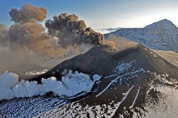
August 18, 2013 eruption of Veniaminof volcano. Ash billows from the intracaldera cinder cone as molten lava streams from two separate vents high on the east flank of the cone. The lower white plume is steam, indicating lava-ice interaction in the ice field that occupies Veniaminof's caldera. Photo credit: R.G. McGimsey, AVO/USGS. (AVO image ID 55101)
Alaska forms the northern portion of the "ring of fire," an area bordering the Pacific Ocean that contains numerous volcanoes that result from partial melting of the earth's crust caused by active plate tectonics. Alaska's Aleutian Arc volcanoes have formed by the subduction of the Pacific Plate under the North American Plate at the Aleutian Trench. In total, the state has over 130 volcanoes (more than any other state) with fifty-four considered to be historically active (active within the last ~300 years).
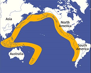
'Ring of Fire'. Image credit: Griffith Observatory.
Because volcanoes in Alaska are distributed over such a large, remote geographic area, monitoring them is a unique challenge. The Alaska Volcano Observatory (AVO) was founded in 1988 and is tasked with monitoring and studying Alaska's volcanoes in order to assess the nature, timing, and likelihood of volcanic activity and to provide timely and accurate information on volcanic hazards to the public to help mitigate damage to life and property. The State of Alaska, Division of Geological & Geophysical Surveys (DGGS) Volcanology Section is part of a joint program that comprises the AVO, which also includes the U.S. Geological Survey (USGS) and the University of Alaska Fairbanks, Geophysical Institute (UAF-GI).
Scientists in Anchorage and Fairbanks conduct geologic field studies to understand the eruptive history of volcanoes and staff at both locations participate in remotely monitoring Alaska's volcanoes via seismic networks, satellite image data, infrasound data, deformation data, and web-cameras. The AVO uses these data to establish the typical background level of activity for monitored volcanoes that are in a non-eruptive state, and to record activity when a volcano becomes restless. The public, air traffic controllers, and other state and federal agencies are informed when there is a change in activity, indicating there may be an impending eruption. This information is conveyed to the public in Volcano Activity Notifications that communicate changes in Volcano Alert Levels and Aviation Color Codes. Volcanic Activity Notifications are published on the AVO webpage, and also offered as a subscription service.
Eruptions in Alaska pose numerous hazards, which include drifing ash plumes, ashfall, lahars and floods, tsunamis and earthquakes, lava flows and domes, volcanic gases, pyroclastic flows and surges, rock projectiles, rockfalls and landslides, debris avalanches, and directed blasts. Alaska's volcanoes are ominously located beneath commercial and recreational airspace. As a result, drifting ash plumes and ashfall are not only a hazard to the cities, towns, and villages downwind of an erupting volcano, but also to the aviation community. Thus, the AVO works closely with agencies including the Federal Aviation Administration (FAA) and National Weather Service (NWS), especially during eruptions, to ensure that aircraft are safely rerouted to avoid volcanic ash plumes. During an eruption, the public are an important source of information for the AVO, with wings in the air or boots on the ground in areas that are often inaccessible to observatory staff during a rapid response situation. Reports from pilots, mariners, and the public greatly inform AVO staff on ash plume heights and trajectories or the locations where ash is falling. The AVO encourages the public to report volcanic observations and to visit the AVO website for information on volcanoes and current volcanic activity in Alaska.

On December 15, 1989, a Boeing 747-400 encountered Redoubt ash and temporarily lost power to all four engines before landing in Anchorage. Photo credit: R. Clucas, AVO/USGS, taken April 21, 1990. (AVO image ID 379)
Numerous glaciers and ice fields occupy the mountain ranges of Alaska, and the processes of glaciation and deglaciation have influenced much of the state's landscape. Outside the two major ice sheets that cover most of Greenland and Antarctica, glaciers in Alaska (and shared ice-fields with Canada) represent about 13 percent of the mountain glaciers and ice caps area on Earth. Glaciers are important fresh water reservoirs and glacier-related tourism is an important part of Alaska's economy.
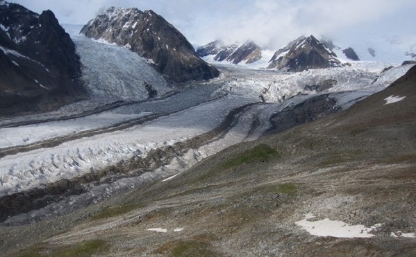
Susitna Glacier in the summertime. Photo credit: Gabriel Wolken, DGGS.
Alaska's glaciers are in steep decline and among the fastest melting glaciers on Earth. In addition to higher temperatures, one of the impacts of climate change on maritime glaciers is an increase in the altitude at which water falls as snow. This means that rain is falling more frequently in high-elevation settings and therefore winter snow accumulation on glaciers is decreasing. This negatively influences the glacier's annual mass balance (the difference between the annual snow accumulation on the glacier and the annual mass loss by surface melting and runoff), which means that the glacier ablates (loses through melting and evaporation) more snow than it accumulates in a year, leading to glacial retreat (see figure below).
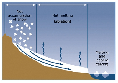
Diagram of a glacier showing components of mass balance. Image credit: U.S. Geological Survey.
The study of glaciers, or glaciology, has been a topic of interest for several hundred years, but today those who research glaciers, or glaciologists, employ many different tools and methods to study glaciers and their response to a changing climate. Glaciologists study many aspects of glacier systems, including how and why glaciers change and the impacts of glacier change on the physical, ecological, and human environments.
Traditionally, glaciologists have travelled up and down glaciers on foot to take mass balance measurements, but today, thanks to widely accessible satellite remote sensing data and ground-penetrating radar, glaciologists can conduct large-scale analysis over large and remote areas. Here at DGGS, the Climate and Cryosphere Hazards Program (CCHP) conducts research on glacier change and its impact on Alaskans. CCHP's glacier-related hazards studies use a combination of field-based observations, remote sensing, and modeling to assess, monitor, and predict the impacts of glacier change on communities, infrastructure, and resources in Alaska.
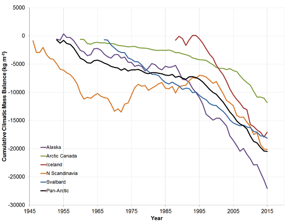
Cumulative climatic mass balances (kg/m2) for glaciers in five regions of the Arctic, and for the Arctic as a whole (Pan-Arctic). Mean balances are calculated for glaciers monitored in each region in each year, and these means are summed over the period of record. Glaciers in Alaska (purple line) have been in steep decline since the late 1980s. Source: Wolken and others, 2017; State of the Climate in 2016.
Glaciers are Alaska's #1 tourist attraction, and Alaskans enjoy them too. A variety of glacier hazards exist in Alaska (e.g. glacial lake outburst floods, calving, glacier surges, glacier collapses) that could impact public safety and infrastructure (Echelmeyer and others, 2002). Ice-dammed lakes are being formed in valleys formerly occupied by glaciers, and if climate change trends continue, more ice-dammed lakes can be expected. CCHP staff monitor the build-up and release of glacial lake outburst floods by conducting photogrammetric surveys and installing remote viewer cameras, weather stations, and water level gages. This equipment provides important information to local authorities, such as estimates of stored water volume and potential outburst flood magnitudes, and the technology to monitor these lakes in real-time. See our Story Map on CCHP's Monitoring Program of Glacial Lake Outburst Floods in Alaska.
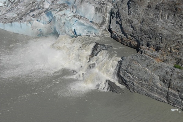
Subglacial outburst flood from Suicide Basin, dammed by Mendenhall Glacier. Photo credit: Eran Hood, UAS.