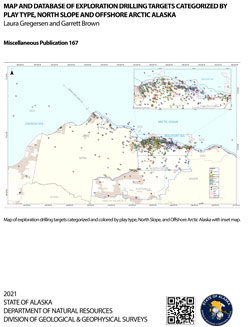
Gregersen, Laura, and Brown, Garrett, 2021, Map and database of exploration drilling targets categorized by play type, North Slope and offshore Arctic Alaska: Alaska Division of Geological & Geophysical Surveys Miscellaneous Publication 167, 15 p., 4 sheets, scale 1:725,000. https://doi.org/10.14509/30579
 Report Information
 Supplemental File(s)
 Maps & Other Oversized Sheets
 Geospatial & Analytical Data
| Map and database of exploration drilling targets - North Slope and Offshore Alaska | Data File Format | File Size | Info |
|---|---|---|---|
| Download mp167-well-data | Shapefile | 63.8 K | Metadata - Read me |
Alapah Limestone; Albian; Arctic Alaska; Arctic Ocean; Atigaru Point; Ayiyak Member; Barrow Sandstone; Barrow Trail Member; Bearpaw Creek; Beaufort Sea; Brookian; Brookian Sequence; Canning River; Carbonates; Chandler Formation; Chandler River; Chukchi Sea; Clastics; Coalbed Methane; Colville River; Cretaceous; Devonian; Drilling; Echooka Formation; Endicott Group; Energy; Exploration; Exploration Well; Fawn Creek; Flaxman Formation; Fortress Mountain Formation; Gas; Gas Hydrates; Geologic; Geology; Grandstand Formation; Gubic Gas Field; Harrison Bay; Heald Point; Hue Shale; Hydrocarbon; Ikpikpuk River; Imikpuk Lake; Interpretation; Itkillik River; Ivishak Formation; Ivishak River; Jeanette Island; Jurassic; Kachemach River; Kalubik Creek; Kalubik Formation; Kavik Shale; Kekiktuk Conglomerate; Kemik Creek; Kemik Sandstone; Key Creek; Kingak Shale; Kogosukruk Member; Kuna Formation; Kuparuk River; Kutchik River; Kuyanak Bay; Limestone; Lisburne Group; Marine Sedimentation; Mayoeak River; McClure Islands; Methane; Mikkelsen Bay; Miluveach River; Miocene; Mississippian; NPRA; Nanuk Lake; Nanushuk Formation; Nanushuk River; Ninuluk Formation; North Slope; North Slope Basin; Oil Basins; Oil Development; Oil and Gas; Oil and Gas Basin; Oligocene; Otuk Creek; Paleocene; Pebble Shale; Permian; Petroleum; Pingok Island; Pitt Point; Point Gordon; Point Mcintyre; Point Storkersen; Prince Creek Formation; Prudhoe Bay; Put River; Putuligayuk River; Red Dog Mine; Reference Information; Regional; Reservoir; Reservoir Evaluation; Resource Assessment; Resource Information; Resources; Rocks; Sadlerochit Group; Sag River Sandstone; Sagavanirktok Formation; Sagavanirktok River; Sakonowyak River; Sandstone; Schrader Bluff Formation; Seabee Creek; Seabee Formation; Sentinel Hill Member; Shale; Shaviovik River; Shelf; Shirukak Lake; Shoreface; Shublik Formation; Sinclair Lake; Slope; Smith Bay; Smith River; Spy Islands; Staines River; Tapkaurak Lagoon; Tertiary; Teshekpuk Lake; Thetis Island; Thompson Sandstone; Tigvariak Island; Toolik River; Torok Formation; Triassic; Tuktu Formation; Tulageak Point; Tuluvak Formation; Turbidites; Ublutuoch River; Ugnuravik River; Umiat Lake; Unga Formation; Wahoo Limestone; Wainwright; Wainwright Inlet; Walapka Sandstone; Wolf Creek; geoscientificInformation


